Sikkim floods: How glacial lake outburst flood (GLOF) led to massive devastation
“It’s distressing.”
“It’s deeply concerning.”
“Pray for the safety and well-being of all those affected.”
These were just some of the reactions after the state of Sikkim saw catastrophic flooding caused by the heavy rain and the glacial lake Lhonak overflowing. The tragedy has led to the deaths of 14 people with 102 others, including 22 army personnel, reported missing.
“So far, 10 bodies have been recovered from different locations. At least 82 more are missing and 22 people are injured, some of them seriously,” Sikkim’s Chief Secretary V B Pathak told Reuters news agency late Wednesday evening.
As the northeastern state of Sikkim and neighbouring areas – West Bengal is also affected – contend with the after effects of the flooding, we take a closer look at what caused the floods and why were they so severe.
Devastation and destruction
Torrential flooding in the area occurred after a cloudburst took place over the Lhonak glacial lake in the state’s north. According to the India Meteorological Department (IMD), the state received 40.9mm (1.6 inches) of rainfall between Tuesday and Wednesday morning – about five times its normal rate of8.6mm (0.3 inches) for this time of the year.
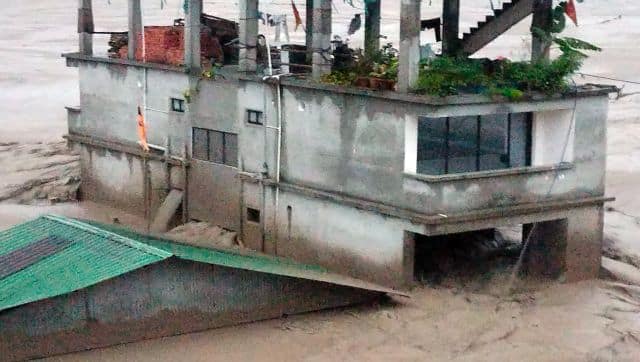
“The intense rain has caused severe damage in Mangan, Gangtok, Pakyong, and Namchi Districts,” said a statement issued by the Sikkim government. It has washed away the Teesta-III dam at Chunthang as well as damaged parts of Teesta-5. Officials have also stated that at least 14 bridges have been washed away and the National Highway 10 (NH10) was damaged in multiple areas.

Prabhakar Rai, the director of Sikkim’s disaster management talking of the tragedy said to Hindustan Times, “North Sikkim has been totally cut off from the rest of the state while Sikkim has been cut off from the rest of India as the flood had badly hit NH10.’
Elaborating further on the damage caused to the dam – Sikkim Urja – Sunil Saraogi, the executive chairman of Sikkim Urja Limited was quoted as telling Hindustan Times that the dam got washed away in just 10 minutes. “We also saw that the 200-metre-long bridge connecting the powerhouse has been washed away. The entire powerhouse has been submerged under water.”
He further said that the damage has resulted in the loss of crores of rupees.
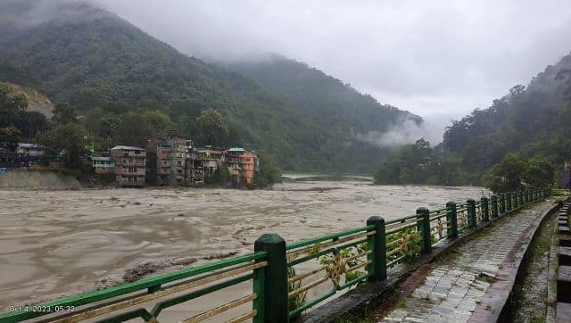
The situation has seen the Teesta River flowing at the “danger level” mark of 298.4 metres in the Khanitar district of East Sikkim, as per the Central Water Commission. The water level in West Bengal’s Jalpaiguri was recorded as “severe” at 85.95 metres.

Mina Tamang, a resident of Singtam, told Hindustan Times, “We rushed out, and in 30 minutes, everything was gone. We couldn’t rescue anything but ourselves. Our entire three storey home was washed away.”
Another resident, Pratima Chettri, told the daily that they fled with nothing but the clothes on their back. “In our area, more than 15 houses were washed away. We exited our homes only with the clothes on our back. We had never imagined that such a catastrophe would arrive and render us homeless.”
Following the tragedy, Sikkim chief minister Prem Singh Tamang urged everyone in the state to remain vigilant. “We are all aware of the recent natural calamity that has struck our state. Emergency services have been mobilised to the affected areas, and I personally visited Singtam to assess the damages and engage with the local community,” Tamang posted on X.
We are all aware of the recent natural calamity that has struck our state. Emergency services have been mobilized to the affected areas, and I personally visited Singtam to assess the damages and engage with the local community.
I humbly urge all our citizens to remain vigilant… pic.twitter.com/KHyylID2pR
— Prem Singh Tamang (Golay) (@PSTamangGolay) October 4, 2023
“I humbly urge all our citizens to remain vigilant and refrain from unnecessary travel during this critical time. It is essential that we maintain composure and hope for a swift return to normalcy in our region,” the chief minister added.
Glacial lake outburst flood and its repercussions
Many believe that the devastating flooding was due to the glacial lake outburst flood of the South Lhonak Lake. But what exactly is a glacial lake outburst flood?
The Lhonak Lake as other glacial lakes are large bodies of water sitting on top of, or beneath a melting glacier. As they grow larger, they become more dangerous. This is because they are blocked by ice or sediment of loose rock and debris. If and when the boundary breaks, huge amounts of water rush down mountains at phenomenal speeds, causing flooding in the downstream areas.

While there is no specific reason why a glacial lake bursts, experts state that an earthquake, heavy rain or an ice avalanche can trigger the phenomenon.
In the case of the Lhonak Lake, scientists believe that it was a disaster waiting to happen. A team from the National Remote Sensing Centre had warned of the dangers of the Lhonak Lake even 10 years ago. The 2013 study had said: “The lake outburst probability shows a very high value of 42 per cent for the lake and peak discharge estimated using the empirical formula shows a discharge of 586 m3/s.”
The study showed that the area of the South Lhonak lake had increased from 17.54 hectares in 1977 to 37.3 ha in 1989, 78.95 ha in 2002 and 98.73ha in 2008.
Another report compiled by the Sikkim State Disaster Management Authority (SSDMA) in 2019 reported that the Lhonak Lake was “highly vulnerable” to a glacial lake outburst flood event, which had the ability to cause extensive damage to life and property in downstream areas. It warned of the possibility of “flash floods” with important infrastructure such as dams and power houses susceptible to damage.
Miriam Jackson, a senior cryosphere specialist at the Nepal-based International Centre for Integrated Mountain Development, was quoted as telling Al Jazeera that such extreme events have become more frequent “as the climate continues to warm and takes us into unknown territory”.

Déjà vu for Sikkim
It’s worth noting here that 55 years ago, to the date, Sikkim had seen a similar situation – floods bringing devastation to the region.
Between 2 and 5 October 1968, the region had received four days of continuous rainfall, which triggered hundreds of landslides, swept houses and bridges and killed around 1,000 people.
Jeta Sankrityayan, former head of the department of economics at North Bengal University told The Telegraph, “The weather cycle coincides almost to the day in 2023 with the events of 1968.”
The incident then had led to the famous Anderson Bridge at the Teesta Bazar being washed away. Fifty-five years later, on Wednesday, the Teesta overflowed at the very spot where Anderson Bridge once stood.
In fact, the 1968 incident is considered one of the biggest calamities the region.
With inputs from agencies
from Firstpost India Latest News https://ift.tt/CrGuseP
FP Explainers
Comments
Post a Comment